
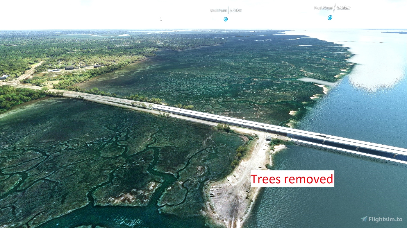
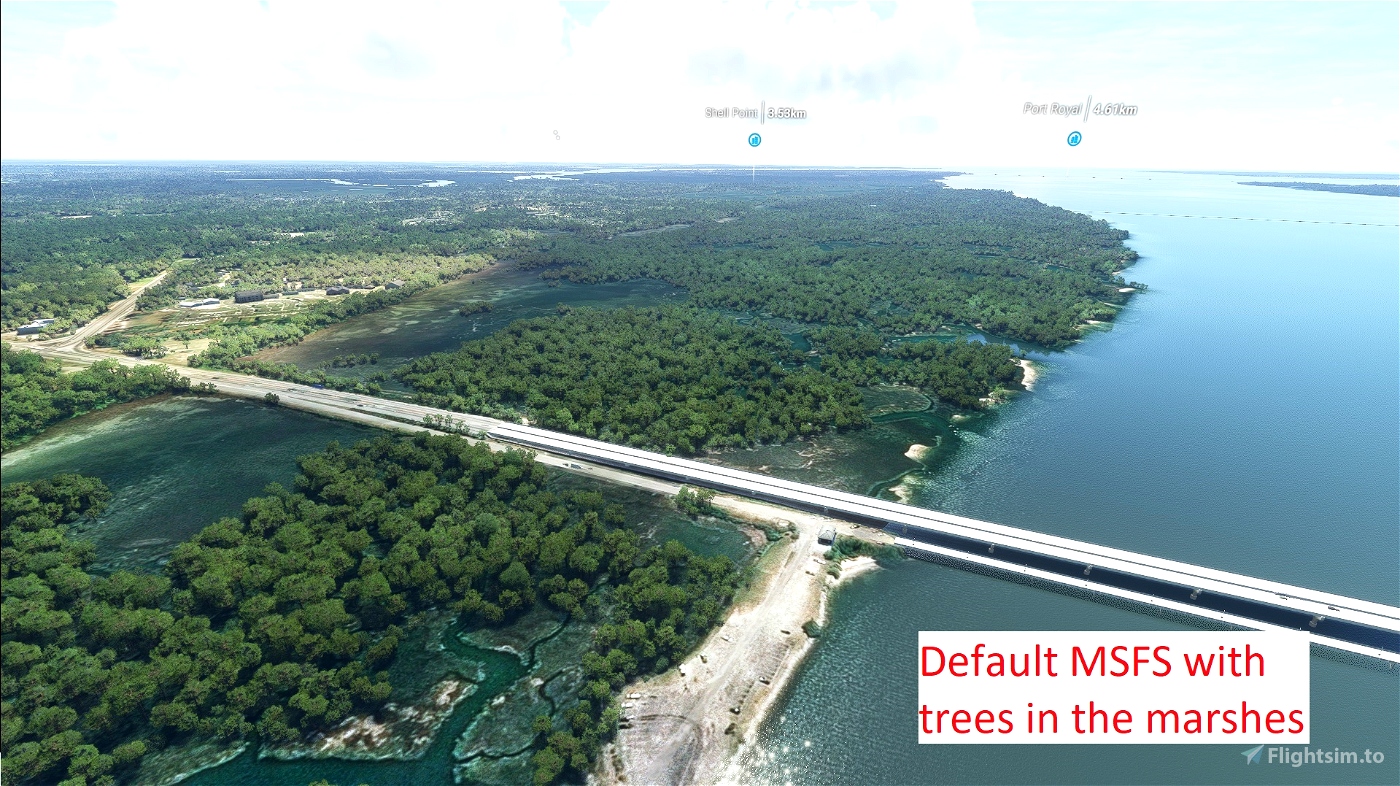

This scenery, remove the trees that are displayed by default in the marshes around Beaufort SC.
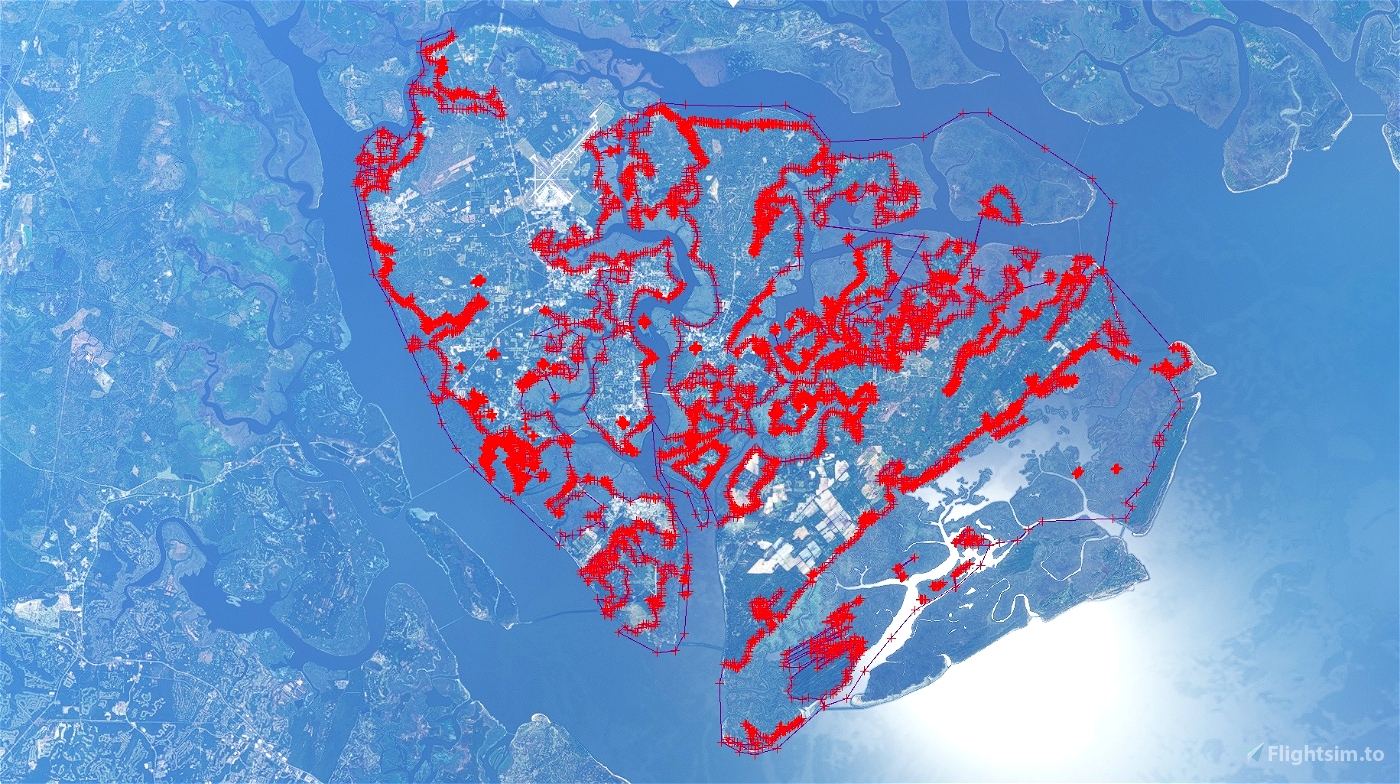
Unfortunately, MSFS displays trees in all the marshes, making them looking more like a mangroves or deep forests. But when you fly in the low countries, and more precisely above Beaufort SC, you see water everywhere. Beaufort County is made of 68 islands separated by rivers, bays, sounds and creeks.
The saltwater covers 51% of the county ( I thought it was more), and you can add 14% for the pounds and lake. At high tide, you'll mostly see the water, and at low tide, the Spartina Grass emerges and swings in the wind. Green in Summer, and Goldish brown in Winter, it's never the same, and what is sure, is that there is no tree if there is no island.
Check on the pictures the differences.
Hopefully MSFS will create soon a Biome "marshland" for all the marshes around the world, because a marsh is not a forest!!!
Just unzip the folder "philusa-beaufort-sc-marshes" in you community folder, and come fly over Beaufort. If you haven't downloaded my bridges and others landmarks yet, give them a try, because from the sky, you really see them first.
Enjoy
PhilUSA


Thanks for this. Currently working on removing the trees in the marshes around Saint Helena, Harbor, Hunting Island and Fripp
2 years ago
This is cool to know that there is another "local" developing Beaufort. I hope we can meet, and share our works.
I did all the marshes between Broad river and Coosaw River, and modeled the bridges on Beaufort river, Battery creek, Broad river and Harbor river. I corrected KARW, but not really hand crafted it, so this is why I kept it for me for now and haven't uploaded it yet. I'm working on what I call " Beaufort's landmarks" which include the Sand's observation's tower, The fish camp restaurant with the docks, most of the water tower around here( I'm sure that I'm missing one or two), most of the radio antennas, the marinas on Beaufort River, with some dolphins jumping here or there. I'm spending too much time on building my own 3D shaped boats library for the marinas
The last MSFS update has change the height and I need many corrections to have everything coming flush again. Even the people on Hunting island light house are hovering a feet out of the fences. Not a big deal seen from the air, but when you come very close you can spot those little misplaced. I hope that next update will not move everything again.
Once I'll be done with Beaufort, I'll try to do the same West of Broad river, to take care of Hilton head and Bluffton.
Unfortunately, I'm not retired, nor hired by Microsoft or ORBX to do the sceneries.
We need to create our Beaufort developer's group.
2 years ago
PhilUSA
mixonk
Excellent job, much appreciated
2 years ago
SteveKirby
I really like the logging that you did in Beaufort. May I ask how you did this? Charleston to the North has quite a few marshes with the same overgrowth. Someone did a scenery to fix the water and hack some trees, but there is a lot to be done still on my side of town, particularly north of the harbor, that I'd like to take a "whack" at or request if nothing else. Thanks again for the clean-up. Cheers!
2 years ago
Hi. I don't know how much you already know about scenery, but I'll assume that you know how to do it. In case you need that part, there are many good video, but I'll recommend Federico Pinotti's video.
To remove the trees, it's very easy, just time consuming.
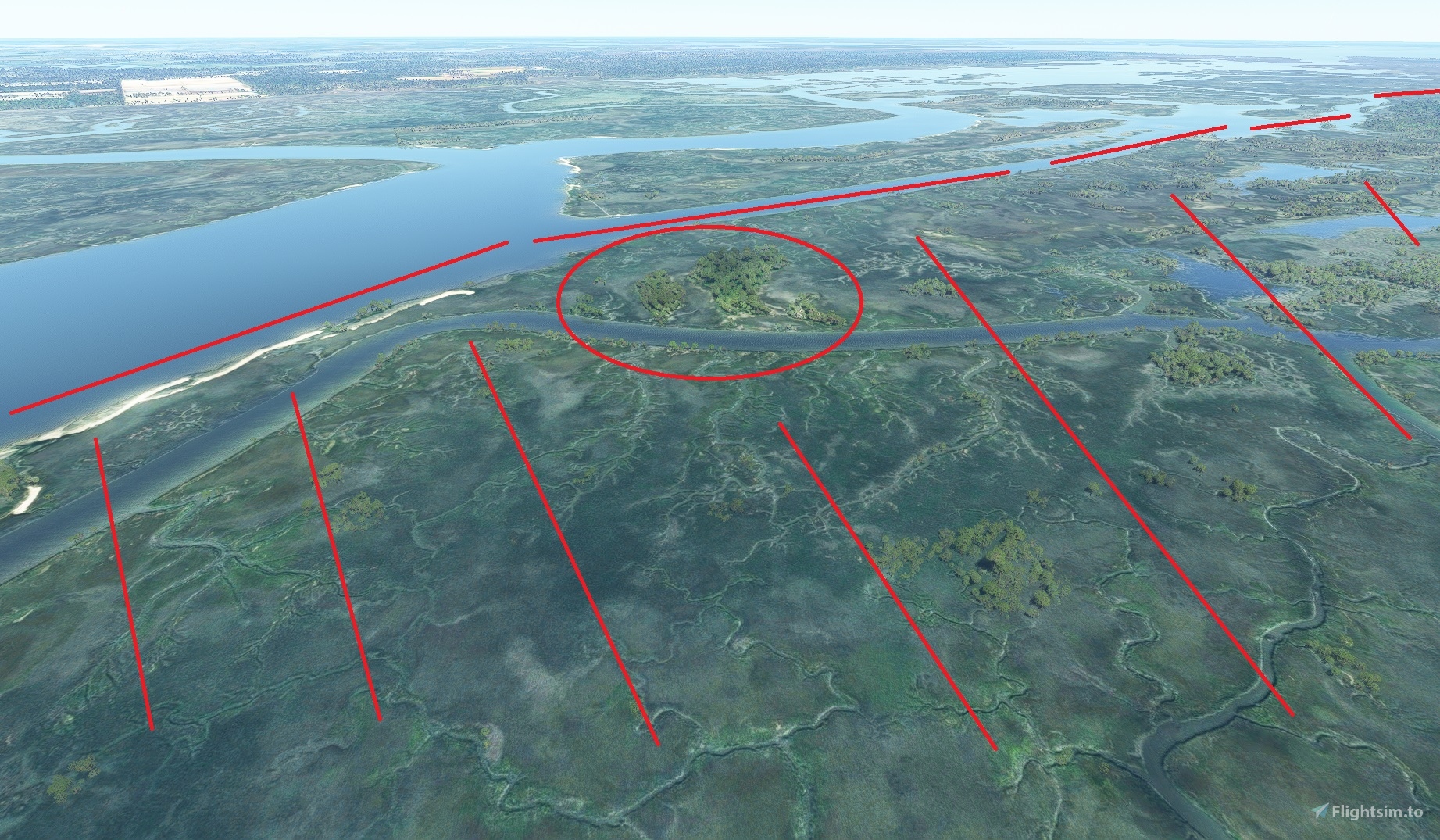
Once in your project, you add a "polygon". Then you follow the shore line by clicking very precisely, until you have a section not more than a thousand points. Smaller sections are easier to work with. I try to take care of one creek at a time.
Then just go in the property window and click on "vegetation", and slide "density", "scale" and "distance" to 0.
If there are islands in the middle of the zone you just cleaned, just add another polygon with "vegetation" on. I add some water too, in the biggest creek, and remove it where the docks and marina are.
It's really too bad that there is no biome "Marshes". Removing the forest from the marshes makes them much more realistic, but if we could have some grass on the side when water landing, it will be even better.
Now add another polygon, and let's go for the next creek. Having google map opened at the same time is a big help when you don't know to much the place. Bing has put forest everywhere there was a cloud, and many parts are missing.
If you know where are the sand bars, you can add a polygon and remove water too. It's too bad that we can't just have transparency for the water. I don't know one river where we can't see those thousand shade of colors depending on how deep. I would fly just to see that.
That's it... or one point more. Don't forgot to share it here, and sorry for having been so long before answering.
Phil
2 years ago
PhilUSA
wacopaco
I really appreciate you doing this!
Can you fix HHI they botched it on the sim, the inter continental waterways are rendering solid with no water and the marsh looks wrong. Don't think Asobo will ever get around fixing this.
2 years ago
The South West side of the Broad River ( HHI, Bluffton) is one of my next zone. Bullfrogsim has done an amazing work on the airport, but the rest of the island need the same improvement than Beaufort ( Marshes, bridges, Marinas and the famous light house.
I'd like to continue to work on Ridgeland Airport where the new building should be built now, and redo the grass, that is a little too perfect.
And I can not let Beaufort co. airport - KARW, as it is by default too.
I have some bridges in Beaufort to upload too. They are mostly done, but I started to work on what's just around.
2 years ago
PhilUSA
marsrocketeer
Much more realistic! Thanks!
2 years ago
Dezerok
Comparing to Google Earth, It looks very similar.... but seems too many trees were removed. Checking your screenshoots, shows no trees, where some should be. Just because its a marsh, it still has some trees. But looks 90%.
2 years ago
Thanks for your comment. I don't know if you live in Beaufort, and if yes let me know where my "chainsaw" have cut a little too much.
I'm often go on the water. There are places that I know very well, and other much less.
You are saying about the picture I have uploaded, and in that part of Beaufort, near broad River, as I can just see it from my backyard, there is no trees in the marsh. In Battery creek near picket fence, there is a forest in the marsh in bing. I went quite often there with my boat and couldn't pictured those trees. I went double check on my boat, and there is absolutely no tree there.
I have found a couple trees that I need to remove near Archer creek, but between St Helena and hunting island and Fripp, many need to come back, and many need to go too. I never navigate on that sound. My goal is to make Beaufort looks more accurate, not still wrong, so if you see a place with mistakes, I really appreciate your comments.
2 years ago
PhilUSA
bloodystub